
Hittin
Updated: Aug 3
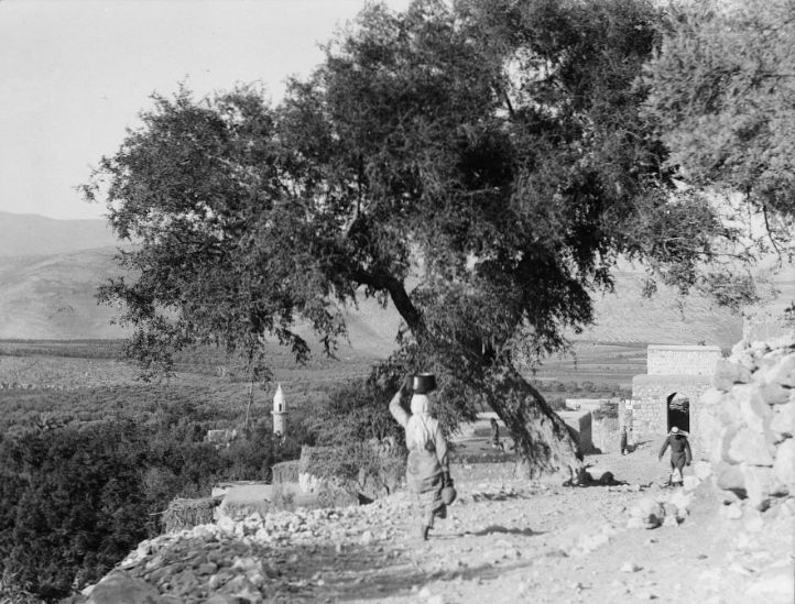
The village was located at the edge of a small valley on the northern slope of Mount Hattin. Historically, the village held significant commercial and strategic importance because it overlooked the Hattin Plain. This plain led eastward to the coastal lowlands surrounding the Sea of Tiberias and connected westward to the Lower Galilee plains through several mountain passes. These plains, with their eastern and western passages, served as routes for trade caravans and military campaigns throughout history.
It is likely that the village was built atop the site of the Canaanite town of Suddim, which acquired the name Kfar Hattin (meaning "Village of Wheat" in Hebrew) in the third century BCE. During Roman times, it was known as Kfar Hanaya and was home to one of the Jewish rabbis in the fourth century CE. The famous Battle of Hattin took place on the Hattin Plain, where Salah al-Din al-Ayyubi defeated the Crusader armies, thereby gaining control over the entire Galilee.
Hattin was also the birthplace or residence of many scholars during the early Islamic period, whose names were linked to the village in the writings of Arab historians and geographers, including Yaqut al-Hamawi (died 1229) and Al-Ansari al-Dimashqi (died 1327), also known as Sheikh al-Hattini. The writer, calligrapher, and Quran interpreter Al-Dawadari died there in 1302.
By 1946, Hattin was a village in the Tiberias Subdistrict, with a population of 605. Its residents paid taxes on various crops such as wheat, barley, and olives, in addition to other products like goats and beehives. The Swiss traveler Burckhardt described it in the late 19th century as a small village with stone houses. By the late 19th century, Hattin was a village with fruit and olive trees, and approximately 400 residents who cultivated parts of the adjacent plain.
The modern village was triangular in shape, with straight, level streets due to the flatness of the site. The village center, located in the northwest, included a small market and an elementary school established around 1897 during Ottoman rule. The village mosque served the entirely Muslim population. A notable religious site near the village was the shrine of the Prophet Shuayb, located on the southwestern outskirts of Hattin. This shrine was particularly revered by the Druze, who made annual pilgrimages to it in April. The shrine included several rooms for visitors and a prayer area believed to contain the tomb and footprint of Prophet Shuayb. A spring near the shrine provided water for visitors.
The land was fertile, with abundant rainfall and groundwater, especially in the northern part of the plain where several springs and wells existed. These factors contributed to a prosperous agricultural economy, with most villagers engaged in farming cereals, fruits, and olives. In 1944, a total of 10,257 dunams were allocated for cereal cultivation, and 1,936 dunams were irrigated or used for orchards.
The village was built atop archaeological remains, which were scattered throughout the site. Nearby, there were also several ruins.
Occupation and Ethnic Cleansing
The first direct combat experience of Hattin’s residents during the war occurred on June 9, 1948, when they repelled an Israeli attack on the nearby village of Lubya just before the first truce. Some villagers interviewed about twenty-five years later recalled that as an Israeli armored unit was retreating eastward, Hattin defenders fired upon the vehicles from positions overlooking the Nazareth-Tiberias road. After forcing the Israeli unit further back, most defenders returned to the village to attend the funeral of a comrade who had fallen in battle. The guards who remained on the twin hills known as the “Horns of Hattin”—two prominent high points separated by a valley and considered part of the ancient battlefield—spotted an Israeli armored unit advancing toward the village from the direction of the Jewish settlement Metsuba. One participant described to Palestinian historian Nafiz Nazzal the ensuing events:
"We joined our guards on the Horns of Hattin. Though we were outnumbered by the attackers, our positions overlooked theirs, allowing us to see all their movements as they advanced toward us. We fought fiercely for nearly four hours, forcing them to halt. A few of us descended the mountain and took cover behind the rocks. When the Israelis opened fire, they thought they had fallen into an ambush and decided to withdraw."
The second attack was launched by the Seventh Sheva Brigade after the first truce ended, during Operation Dekel in the Acre District. Historian Nafiz Nazzal reported that after the fall of Nazareth on July 16, approximately twenty-five to thirty soldiers of the Arab Salvation Army began withdrawing from positions in Hattin. Most villagers fled on the night of July 16–17 toward Yassilma, located between Deir Hanna and al-Maghar.
One of the fighters who stayed behind described the events of that night:
“We held our position on the Horns of Hattin until the last minute, watching the Israeli armored unit advance. We were few and poorly armed to resist the attack. During the first Israeli attack, many villagers exhausted their ammunition. We then withdrew to the village and fled northward with a small number who remained.”
Following the occupation of the village, the second truce came into effect. In the days that followed, five men returned to assess the possibility of reclaiming the village but were fired upon by Israeli soldiers. At least one succeeded in returning and helped his family evacuate the village. Villagers also reported having stayed on the outskirts of the village for a month, waiting for an opportunity to return home before ultimately relocating to Lebanon.
The Village Today
The site is now overgrown with weeds, with scattered piles of stones. Aquatic plants grow in the shallow waterways crossing the area. The mosque remains abandoned, with its minaret intact but its arches beginning to crack. Mulberry, fig, eucalyptus, and prickly pear plants cover the site. The surrounding mountainous lands serve as grazing areas for livestock. The shrine of the Prophet Shuayb, situated on a nearby hill, continues to be a pilgrimage site for the Druze.
Israeli Settlements on Village Lands
Israel established the settlement of Arbel (196246) north of the village site in 1949. The settlement of Kfar Zemini (193246) was established a year later northeast of the site. Both are located on lands that once belonged to the village. The settlements of Kfar Hittim (197245), founded in 1936 to the east, and Menashe (197243), also to the east, are near the village site but not on its lands.


Comments